General Aspects:
This facility allows to localize a transmitting station, e.g. an intruder or QRMer by means of bearings taken from two separated reception posts. Good results will be obtained if the baseline between the receiver positions matches the distance to the unknown source. As a rule of thumb the distance should not exceed the length of the baseline by a factor of 3 to 5 times. Furthermore, the bearings from the search positions should not result in almost parallel lines ( in planar geometry ) which yield an acute angled triangle. In these cases, the intersection of the bearing lines would occur at very large distance resulting in considerable estimation errors.
Applying true spherical mathematics the cross bearing facility in TurboLog 4 will yield reliable results within about a quarter hemisphere centered on the receiver positions ( range up to about 10000 Km ). This limit is caused by ambiguities of the angular functions, in particular the arc tangent. More could be done mathematically but at the price of examining all possible solutions. This is beyond the scope of our analysis. Thus we restrict ourselves to the region of unique solutions. Of course there is no lower limit. Thus, the facility is very well suited for carrying out direction finding and localization in VHF Very High Frequency and UHF Ultra High Frequency applications with ranges between a few Km and several 100Km.
Furthermore, this facility allows an easy conversion of geographical coordinates to Maidenhead Locators and vice versa.
How to Start:
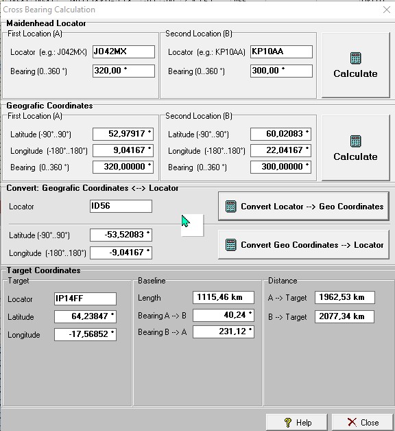
The global short cut Ctrl+B ( B for Bearing) will allow you to surface the Cross Bearing frame from anywhere in TurboLog 4:

Figure 411: The Cross Bearing Frame
You will only need to enter data either into the Maidenhead or the Geographic Coordinates sub frame. After you finished entering sufficient and consistent data into the blank fields you will realize the Calculate button becoming active. Pressing the Calculate button will start the calculation and the results are displayed in the Target Coordinates sub frame.
Maidenhead Locator:
Using Maidenhead Locators is a fast way of entering the receiving positions. While the precision is slightly reduced depending on your location on the globe these entries are absolutely sufficient for shortwave applications where the bearing cannot be accurate to a degree or so. When you enter locator data the related geographic coordinates are automatically computed in the sub frame below (and vice versa).
Locator:
For ease of operation the default locator for receiving position "A" is your entry on the General tab sheet of the log setup. Data from position "B" must be communicated by radio or via the internet Packet system.
Bearing:
Bearing must be entered in the range of 0°...360° where 0° is your local direction to the geographic North Pole.
Calculate:
Press the Calculate button upon completing all entries in order to receive the Target Coordinates shown in the lower group box of the frame.
Geographic Coordinates
Geographic Coordinates will allow to calculate the most precise target location. Use of these entries is recommended if data is available and if good bearing data can be measured. After you have completed entering the data fields the related locator information will be displayed in the sub frame above.
Latitude:
Enter latitude data where the positive sign stands for Northern Latitude and the negative sign stands for Southern Latitude.
Longitude:
Enter longitude data within the range of -180° ... +180°. East of Greenwich is positive longitude, west of it is negative.
Bearing:
Bearing must be entered in the range of 0°...360° where 0° is your local direction to the geographic North Pole.
Calculate:
Press the Calculate button upon completing all entries in order to receive the Target Coordinates shown in the lower group box of the frame.
Convert Geographic Coordinates <--> Locator
Independent from cross bearing data this utility allows you to convert geographical coordinates to Locator and vice versa. Just enter the data you have and press the assigned Convert button.
The example shows the locator entry ID56 which converts to the geographic coordinates shown right below.
Target Coordinates:
All target data is displayed in the lower sub frame.
Target:
The target is given by its Maidenhead Locator and by its Geographical Coordinates.
Baseline:
The distance between the 2 receiving posts is displayed along with the bearings from position "A" to "B" and vice versa.
Distance:
This displays the range from both positions "A" and "B" to the target location.
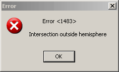
In case there is no intersection of the bearings within the unambiguous range of the angular functions or another mathematical problem in spherical geometry the following error message will be displayed:

Figure 412: Prompt for Ambiguous Solution
Active Commands:
KEYS/HOTKEYS:
| Ctrl+B | Globally: Opens the Cross Bearing facility. |
BUTTONS:
| Calculate | Starts calculating |
| Convert | Starts converting |
| OK | Confirm prompt |
| Help | Opens this Help topic. |
| Close | Closes the frame. |
This topic was last edited on Thursday, 12-Dec-2024, at 13:30